


 8 / 52


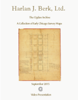
Butler, Wright and Webster’s Addition to Chicago
By:
Asa F. Bradley
Date:
September 22, 1839
Dimensions:
19 x 16 inches (48.25 x 40.6 cm)
Signatures:
Charles Butler, Hosea Webster and Amasa Wright. Also signed by Timothy Barlow
This map is an excellent representation of the first population boom the city of Chicago went
through. What started as a town of 350 in 1833 became incorporated as a city in 1837 and by the
year 1840 had a population of over 4,000 residents. That’s an increase of nearly 2,000 % in just
seven years.
This particular map shows a 40 acre property just east of the North Branch of the Chicago River
extending from Kinzie Street to Chicago Avenue. The originally purchased by John Stephen
Wright on Jan 2, 1835 for $4000, this property was officially sold just 4 months later in New
York on April 10 for $10,000. The buyers of the property were New York land investors Charles
Butler, Amasa Wright, and Hosea Webster. The map shows the 378 lot parcel divided nearly
equally between them with curiously just one lot remaining unclaimed. The surveyed portion is
hand colored with designations and lot sizes. A light sketch of a stream and wagon road appears
running through the map.
The map also marks the first known example of a land survey produced by Asa Bradley, Cook
County’s first Public Land Surveyor.
His script reads as follows:
I hereby certify that I have surveyed and that the annexed plat is a true representation of
the newest half of the North East quarter of section No. nine in township No. thirty-nine North in
range No. fourteen East of the then principal Mrdn Ill. It is laid out into Streets Blocks and lots
as appears per Plat.
Asa Bradley
Chicago Sep 22 1839 Cook County Surveyor
Condition:
Hand colored manuscript map with linen backing contemporaneous with the
piece. Missing section in lower left with several breaks along the folds. Note from the
county clerk on the verso, indicating the recording of the map, signed by Eli B. William.